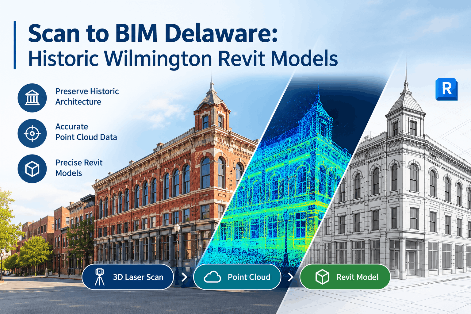
Historic buildings form the soul of Wilmington, Delaware. From the nineteenth-century industrial architecture along the Christina Riverfront to the grand Victorian and Federal-style estates lining the Brandywine, these structures represent rich cultural heritage. However, restoring, expanding, or retrofitting these aged marvels presents immense technical challenges. Traditional paper drawings are often inaccurate, incomplete, or entirely missing. Carrying out manual field measurements on weathered masonry, sagging timber frames, and hand-crafted ornamental details frequently introduces costly human errors.
To overcome these structural complexities, architects, engineers, and historic preservationists turn to Scan to BIM Delaware workflows. By converting millions of spatial data points into intelligent digital models, Scan-to-BIM Wilmington projects bridge the gap between historic craftsmanship and modern construction technology. Leveraging high-definition reality capture, specialists transition raw scan files into an actionable point cloud to Revit Wilmington pipeline. This process establishes a precise digital foundation that streamlines project delivery, eliminates field surprises, and protects irreplaceable architectural assets.
The Architectural Heritage of Wilmington and the Need for Precision
Wilmington’s urban landscape reflects over three centuries of North American architectural history. Key districts showcase diverse building methods and specialized structural assemblies:
- The Riverfront & East Side Industrial Architecture: Heavy timber construction, load-bearing brick masonry, and structural cast-iron columns requiring precise load distribution analysis.
- Trolley Square & Market Street Commercial Corridor: Victorian facades, ornate terra-cotta embellishments, structural stone archways, and altered floor levels due to decades of adaptive modifications.
- Brandywine Village & Historic Residential Neighborhoods: Colonial and Federal-style residential properties featuring non-standard timber joist spacing, sagging ceiling planes, and stone foundations.
Documenting these structures using legacy paper blueprints creates significant operational risks. Most historic buildings in New Castle County have undergone multiple unrecorded renovations. As a result, relying on outdated paper records almost guarantees hidden site clashes once active construction begins.
The Challenge of Preserving Historic Architecture in Wilmington
Wilmington’s historic building stock presents distinct structural and physical conditions that disrupt standard renovation strategies. When renovation teams rely on legacy CAD files or physical tape measurements, they encounter severe limitations:
- Geometric Deformations: Aging brick, stone, and wood structures settle over time. Walls tilt, floors bow, and right angles rarely exist. Standard design assumptions fail in these real-world conditions.
- Inaccessible Architectural Features: Soaring ceilings, ornate cornices, vaulted arches, and intricate facades are difficult to measure safely using traditional ladders or scaffolding.
- Inaccurate Historical Records: Renovations executed across different decades often lack updated documentation, causing unexpected clashes during mechanical, electrical, and plumbing (MEP) installations.
- Preservation Constraints: Strict heritage regulations mandate minimal physical disturbance to existing fabric. Invasive exploratory demolition can destroy irreplaceable historic elements.
Deploying a dedicated historic building BIM strategy eliminates these risks. Rather than forcing non-standard structures into rigid theoretical shapes, reality capture records every physical nuance exactly as it exists today.
What is Scan to BIM? From Field Capture to Intelligent Modeling
The Scan to BIM process replaces manual surveying with high-definition digital measuring. It systematically records real-world conditions and translates them into an object-oriented 3D building information model.
- Reality Capture: Surveyors deploy terrestrial laser scanners to capture spatial coordinates.
- Data Registration: Millions of individual points are registered into a single, unified coordinate system.
- Revit Modeling: BIM specialists import the point cloud into Autodesk Revit to build parametric architectural, structural, and MEP components.
- Validation & Quality Control: The model is audited against the original scan data to ensure target tolerances are met.
Core Technologies Powering Scan to BIM Delaware Projects
Executing accurate Scan to BIM Delaware initiatives requires advanced hardware and software workflows working in tandem.
1. 3D Laser Scanning
Modern 3D laser scanning equipment uses LiDAR (Light Detection and Ranging) technology to emit hundreds of thousands of laser pulses per second. These pulses reflect off surrounding surfaces, capturing millimeter-accurate X, Y, and Z spatial coordinates. The result is a non-destructive survey method perfectly suited for fragile historic surfaces.
2. Point Cloud Data Processing
The raw output generated by laser scanners is point cloud data. Files stored in formats like .E57, .RCP, or .LAS contain dense visual representations of the structure. Advanced processing software registers multiple scan positions, removes environmental noise (such as moving vehicles or pedestrians), and indexes the project for smooth import into modeling software.
3. Mobile LiDAR and Photogrammetry Integration
For complex sites with obstructed spaces, survey teams combine terrestrial static scanners with mobile LiDAR mapping and high-resolution photogrammetry. Drone photogrammetry captures intricate rooflines, slate tile details, and high-level masonry elements, filling data gaps that ground-based scanners cannot reach.
4. Autodesk Revit Platform
Once indexed, point clouds are opened directly inside Autodesk Revit. BIM technicians use these precise geometric references to build parametric families, walls, roofs, structural beams, and decorative elements.
Step-by-Step Workflow: Point Cloud to Revit Wilmington
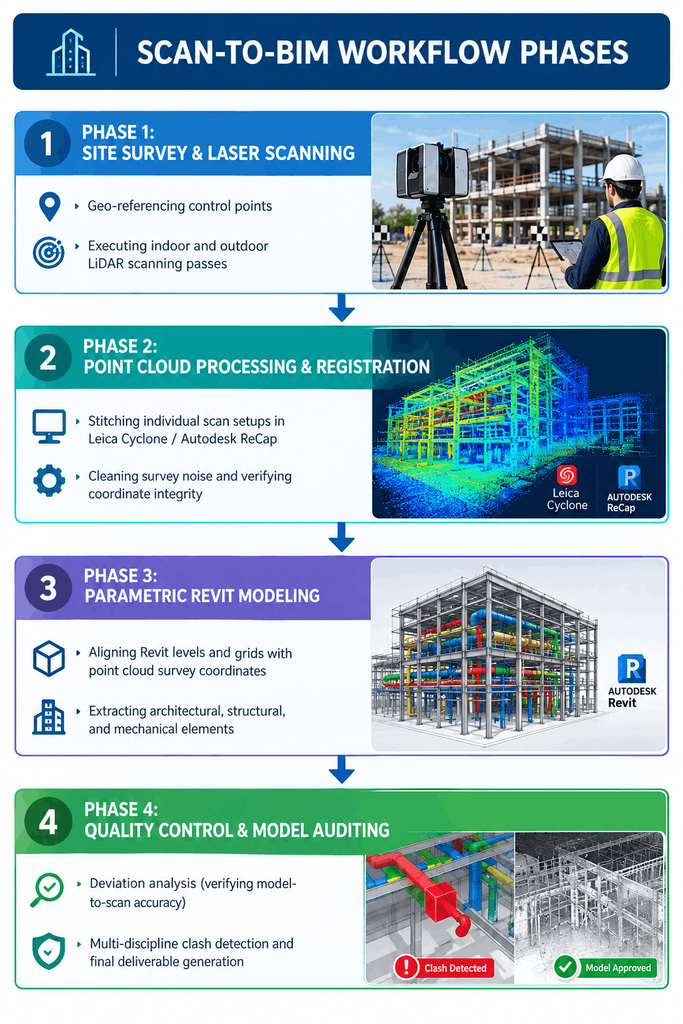
Converting raw scan data into an actionable BIM asset follows a structured, multi-phase technical workflow:
Phase 1: Site Survey & Reality Capture
Experienced field teams conduct a pre-scan assessment of the historic site. Target locations are established using survey-grade control points, and high-definition laser scanners collect internal and external geometry—including hidden roof trusses, narrow crawlspaces, basements, and utility vaults.
Phase 2: Processing and Registration
Individual scan setups are stitched together using software like Leica Cyclone or Autodesk ReCap. The registered point cloud is cross-checked against control targets to guarantee tight global accuracy across the entire structure.
Phase 3: Revit As-Built Modeling
The registered scan data is imported into Autodesk Revit. BIM engineers author parametric elements—such as load-bearing masonry walls, timber joists, window architraves, and MEP runs—directly over the scan points.
Phase 4: Quality Assurance and Deviation Analysis
Automated deviation tools compare the newly modeled Revit elements against the underlying point cloud. Any geometry exceeding client-specified tolerances is flagged and adjusted, guaranteeing a true-to-life digital duplicate.
Specifying the Right Level of Detail (LOD) for Historic Structures
Selecting the correct Level of Detail (LOD) is essential for balancing project budgets, modeling speed, and detail requirements.
| Level of Detail | Primary Purpose | Architectural & Structural Representation |
| LOD 200 | Conceptual Planning & Feasibility | Generic spatial masses, approximate wall locations, basic roof slopes, and general floor elevations. |
| LOD 300 | Design Development & Approvals | Accurate wall thicknesses, precise door/window openings, structural framing, and exact component dimensions. |
| LOD 350 | Construction & Systems Coordination | Detailed connection interfaces, precise historic molding profiles, custom steel bracing, and cross-discipline clash resolution. |
When modeling historic landmarks across Delaware, projects often blend LOD specifications: basic structural assemblies use LOD 200 or LOD 300, while complex facade ornamentations, historic wood millwork, and custom ironwork require LOD 350 modeling.
Key Benefits of Scan-to-BIM for Historic Preservation and Adaptive Reuse
Applying historic building BIM workflows offers immediate advantages for property owners, developers, and design firms.
1. Supporting Historic Preservation Standards
Historic preservation demands non-invasive documentation. Laser scanning captures every architectural nuance without physical contact. The resulting as-built model preserves a digital archive of the building’s original state prior to any physical intervention, ensuring compliance with local Delaware SHPO (State Historic Preservation Office) guidelines.
2. Streamlining Adaptive Reuse Projects
Repurposing old industrial plants or historic commercial buildings into modern residential spaces requires fitting complex modern systems into tight spaces. A precise Revit as-built modeling workflow allows engineers to route new HVAC, electrical, and plumbing infrastructure around existing structural elements without field modifications.
3. De-risking Renovation Budgets
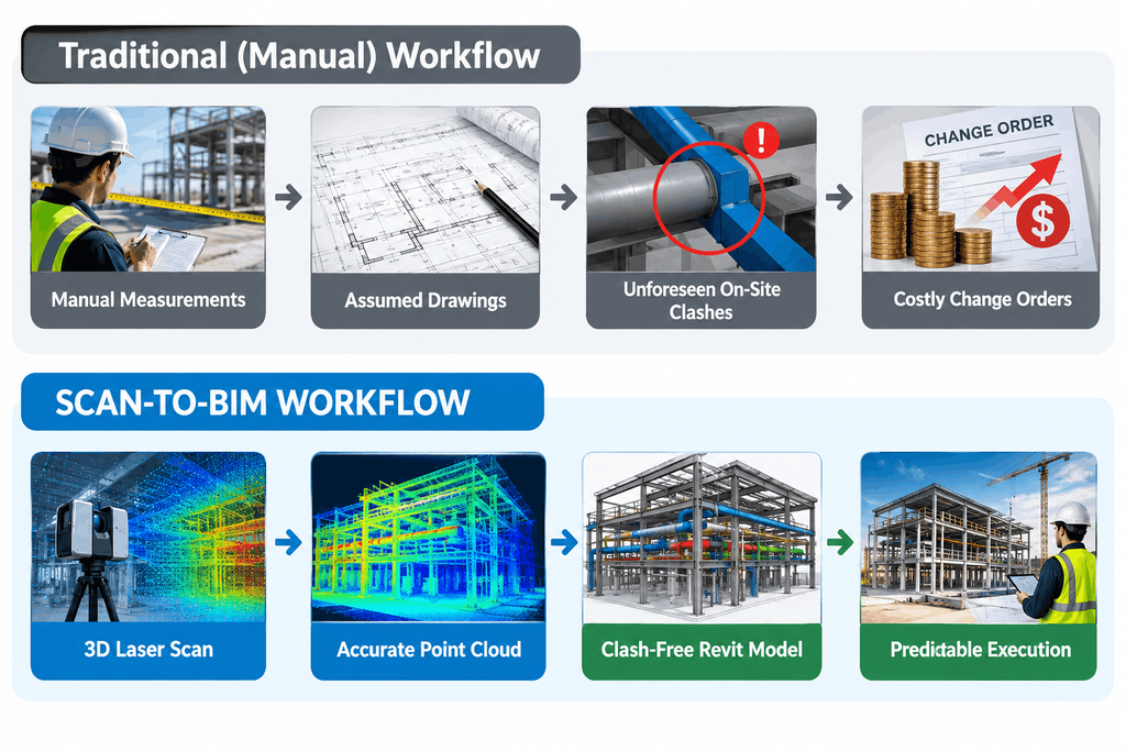
Undocumented structural deviations are a primary cause of costly construction change orders. By establishing a clear digital record up front, design teams identify structural deformities, clashes, and spatial constraints during pre-construction rather than during demolition.
TRADITIONAL SURVEY WORKFLOW
4. Optimizing Structural Stability Assessments
Historic brick masonry and wood framing experience material degradation over time. Structural engineers can import scan-derived geometry directly into structural analysis platforms to simulate load paths, assess shear risks, and engineer modern structural retrofits without damaging surrounding fabric.
Overcoming Complexities in Historic Revit Modeling
Modeling historic features in BIM requires custom techniques that go beyond standard modern BIM templates:
- Deformed Walls and Floors: Standard Revit walls are strictly vertical. For leaning historic walls or sagging floors, BIM specialists use sloped wall parameters or custom adaptive components matched to point cloud slices.
- Irregular Custom Trim and Moldings: Custom in-place sweeps or adaptive families are generated from point cloud cross-sections to match historical millwork profiles accurately.
- Timber Truss Assemblies: Aged heavy timber trusses often feature irregular bow vectors. Technicians create individual parametric wood framing elements aligned precisely to spatial coordinates.
Integrating Scan to BIM with Digital Twin Technologies
The value of reality capture extends beyond construction completion. When an accurate point cloud to Revit Wilmington model is linked to real-time IoT sensors and building management platforms, it evolves into an operational asset.
By leveraging AcuraBIM Digital Twin Services, facility managers overseeing historic Delaware properties can monitor environmental parameters, manage thermal performance, and plan preventive maintenance programs without damaging historical materials. This integration turns passive historical documentation into an active, intelligent asset management system.
Practical Applications Across Delaware Preservation Projects
Scan-to-BIM applications span multiple project types throughout Wilmington and the broader Delaware region:
- Commercial Adaptive Reuse: Converting nineteenth-century bank buildings or industrial warehouses into boutique hotels, modern office suites, or retail spaces on Market Street.
- Institutional Renovations: Updating aging university facilities, government centers, and museum properties to satisfy modern ADA accessibility, life safety, and energy efficiency standards.
- Residential Historic Preservation: Restoring landmark residential estates, ensuring exterior facades and custom interior woodwork meet historic district overlay restrictions.
Why Choose AcuraBIM for Your Delaware Scan to BIM Projects?
Executing high-precision reality capture modeling requires specialized expertise, rigorous quality control, and deep domain knowledge. As a trusted provider of global AEC solutions, AcuraBIM Services brings technical excellence to historic preservation and adaptive reuse endeavors.
- Domain Expertise: Over 12 years of experience completing 250+ BIM projects across international markets.
- High Precision: Advanced point cloud registration protocols ensure tight model accuracy.
- Multi-Disciplinary Integration: Full capability across architectural, structural, and MEP disciplines to eliminate cross-trade conflicts.
- Tailored LOD Execution: Customized modeling workflows from LOD 200 to LOD 350 tailored to client deliverables.
- ISO 9001:2015 Certified Quality: Standardized QA/QC processes verify every element against raw scan data before delivery.
Explore our comprehensive modeling capabilities by reviewing AcuraBIM Structural Modeling Services to see how our team handles complex structural conditions.
Transform Your Historic Delaware Project with AcuraBIM
Restoring or repurposing a historic landmark in Wilmington requires absolute spatial accuracy. Don’t leave your project outcomes to outdated drawings or manual field checks. Partner with AcuraBIM to convert complex point cloud data into accurate, clash-free Autodesk Revit models that save time, reduce rework, and safeguard architectural history.
Ready to digitize your historic asset? Contact our expert BIM team today to request a custom quote and discover how our Scan to BIM Delaware services elevate your design workflow.
Frequently Asked Questions (Q&A)
What is the primary advantage of Scan to BIM over traditional surveying for historic buildings?
Scan to BIM captures millions of precise 3D points non-destructively, recording real-world conditions—including bowing walls, non-standard angles, and settling—that traditional manual surveying methods miss. This provides an accurate digital baseline for design and construction.
How accurate is point cloud data captured from 3D laser scanners?
Modern terrestrial laser scanners deliver millimeter-level accuracy. When properly registered with ground control points, the resulting point cloud provides an exact spatial representation of the physical structure.
Which file formats are used when importing point clouds into Revit?
Autodesk Revit primarily uses .RCP (ReCap Project) and .RCS (ReCap Scan) formats. Universal formats like .E57, .LAS, or .PTS can easily be converted into .RCP format using Autodesk ReCap prior to modeling.
What Level of Detail (LOD) is recommended for historic building BIM projects?
Most historic preservation and adaptive reuse projects utilize LOD 300 for general architectural and structural elements, and LOD 350 for intricate historic features, custom timber frames, or detailed facade ornamentation where structural connections matter.
How does Scan to BIM assist with adaptive reuse projects in Wilmington?
In adaptive reuse, modern MEP systems must be integrated into historic spaces. A precise Revit as-built model allows engineers to detect mechanical clashes in a virtual environment before construction begins, preventing damage to historic materials and avoiding expensive field revisions.
Can non-vertical historic walls be modeled accurately in Autodesk Revit?
Yes. Using advanced modeling techniques—such as slant wall features, adaptive component families, or massing elements generated directly over point cloud cross-sections—specialists can accurately model leaning or irregular historic masonry without simplifying the geometry.
How does Scan to BIM support compliance with Delaware historic preservation standards?
Detailed 3D models document historic fabric non-invasively before any physical modifications occur. These digital records provide clear visual documentation required by historic preservation commissions and State Historic Preservation Offices (SHPO) for grant applications and tax credit approvals.
Can AcuraBIM model MEP and structural elements from point clouds?
Yes. AcuraBIM provides complete multi-disciplinary Scan to BIM conversion, modeling structural framing, architectural envelope details, and exposed MEP infrastructure from point cloud scans.